Data on water conditions are feeding digital tools to solve myriad planning problems.
Divining rods—really, just forked sticks—supposedly tremble when you hold them over any ground that conceals water below. Whether or not you subscribe to their seemingly magical, analog effectiveness, you might be thinking, isn't there an app for that?

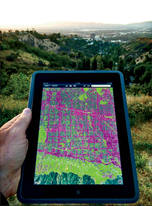
Peter Arnold is working on it. As a founding codirector of the Arid Lands Institute at Woodbury University in Burbank, California, Arnold and his colleagues have developed the proof of concept for an app—Divining LA— that will make it easier for the city to assess the impact of land-use decisions on regional watersheds.
“Cities are designed to shed storm-water off their surfaces very rapidly, but there aren't many tools available to help us examine how we could change the urban fabric to recover more of these resources,” Arnold says. “How do decisions made at a small scale affect the overall hydrological network?”
The app builds on Arid Lands Institute's ongoing research into water scarcity and quality—problems that are becoming increasingly urgent as cities worldwide face dwindling supplies and decaying infrastructure. Identifying low-impact investment opportunities to improve watershed health or reduce economic and environmental risk has inspired several new tools to assess the interaction between water and development.
The Divining LA app is conceived as an open-source computational engine that makes use of a variety of public data on storm and groundwater conditions, surface porosity, topography, site contamination, and soil quality to improve design and planning choices. It also provides additional analysis of water metrics such as quality, supply, embodied energy, carbon emissions, and economic implications. The visually rich app is devised for architects, planners, landscape architects, and engineers, but is being developed with partners like the City of Los Angeles Bureau of Engineering, Perkins+Will, and AC Martin, with pro bono input from Arup (where this author is employed).
Built on a geographic information system (GIS) platform with embedded climate and land-use data, the app could conceivably permit an architect to test strategies like converting a conventional asphalt parking lot to a pervious pavement system and quickly analyze how it would affect upstream and downstream components of the watershed. Arnold says the tool was purposely created to ignore political boundaries—notorious in Southern California for blindly slicing through ecosystems to establish separate municipalities with often distinctly different policies toward treating watersheds.
While Divining LA translates water concerns into potential design opportunities, other tools focus more directly on identifying risks, so that businesses can address more fundamental operations questions about the true impact of consumption in a given location. The Water Risk Monetizer, a web-based tool introduced in November by Ecolab and Trucost, calculates a risk-adjusted price for water that accounts for both its local market price and the value given anticipated scarcity for a particular watershed. Emilio Tenuta, Ecolab's vice president of corporate sustainability, says the Monetizer should help designers understand the potential for a future water crisis at a project site and advise a client on the benefits of investing early in mitigation strategies. “If we don't monetize water, it won't be managed,” Tenuta says.
Less inspired by design or economic issues, the Global Water Tool of the World Business Council for Sustainable Development (WBCSD) provides an environmental footprint for water consumption at a given site. The tool, which is publicly available at no charge, was developed with the WBCSD by the global engineering company CH2M Hill to help users calculate, from simple data for freshwater and non-freshwater consumption, a range of metrics for scarcity and quality. Julie Oesterlé, the water manager for the WBCSD, says the tool is undergoing constant refinement, particularly relating to climate-change forecasts. “The use of tools is a first step in the corporate management of water challenges, which must be followed by holistic approaches and recognition it is part of a 'core business,' ” Oesterlé says.
Like other tools, the Global Water Tool draws on public databases for water and sanitation for most countries. Its output includes metrics that conform to the Global Reporting Initiative's sustainability guidelines, including those for total water withdrawn, discharged, and reused. Such data typically inform annual sustainability reporting and continuous benchmarking, both of which can be useful when a building owner has multiple assets or operates in a competitive market where environmental performance plays a significant role.
Of course, there are other tools available for assessing water issues, but these three illustrate how so-called big data is empowering designers to better understand the environmental context of their projects. “Water risks cannot and should not be managed in isolation from other impacts,” says Oesterlé.
Kinetic Architecture: Designs for Active Envelopes


Post a comment to this article
Report Abusive Comment