A preliminary damage assessment map for major buildings and infrastructure in Port-au-Prince is now available from the United Nations Institute for Training and Research's Operational Satellite Applications Programme (UNITAR/UNOSAT).
Sites marked as "No Visual Damage" may have major structural damage not identifiable in the imagery. Damage there is likely underestimated. The same goes for road and bridge damage, says the group.
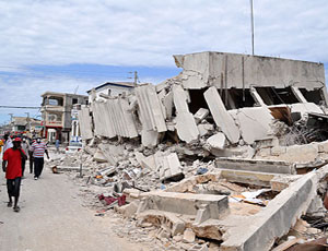
Of 110 selected sites, 58 or 53% are visibly damaged or destroyed. Of these, 88% are government buildings; 60% are churches, 50% are offices and 42% are hospitals.
The major buildings and urban facilities were assessed for damages using GeoEye-1 satellite imagery, recorded on Jan. 13. On the maps, building sites have been identified by local name and classified by type when possible, with a focus on hospitals, government and United Nations offices, schools, churches and industrial complexes.
Damage classes have been assigned based on visual interpretation of available satellite imagery and thus contain an associated level of uncertainty for buildings with less severe forms of damages. Major sites evaluated are not exhaustive of all important buildings within the city.


Post a comment to this article
Report Abusive Comment