The unofficial theme of geography and mapping firm Esri’s fourth-annual Geodesign Summit might as well have been “the cloud.” Nearly every presenter at the event, held on January 24th and 25th in Redlands, California, referred to the decentralized, virtual network of software and data storage as the key factor in the growing importance of geographic information systems systems (GIS). The summit brought together architects, engineers, geographers, and software programmers for presentations focused on software like Esri’s ubiquitous ArcGIS and for discussions about how such tools will eventually, if not quite yet, underpin landscape, urban, and planning design projects.
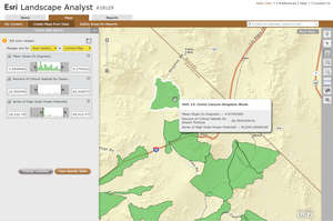 |
| Image courtesy Esri With the beta version of Esri’s Landscape Analyst, designers can develop maps based on a variety of public data sets. In this example, the software was used to identify the location for a photovoltaic system in the Mojave Desert that would optimize electricity generation and minimize the impact on natural habitat. |
Dave Bartlett, who leads IBM’s Smarter Buildings initiative, presented a case study the company developed with the Los Angeles Unified School District. The study combined a smart phone photo application with GIS data and allowed students and teachers to document maintenance issues in the district’s facilities. “People are the smartest sensors we have,” Bartlett said. Christian Gass, a planner with the Canadian firm O2 Planning and Design, presented case studies of three Canadian cities that modeled the impact of proposed design and master plan guidelines on physical development. The virtual neighborhood scenarios were then evaluated against triple bottom line metrics for social, environmental, and economic performance.
Eric Wittner, an Esri solutions engineer, discussed the company’s work with the City of Honolulu to visualize the potential urban densification around a proposed rail line. Bern Szukalski, an Esri product strategist, demonstrated new tools—Community Analyst, a beta version of Landscape Analyst, and Story Maps—that rely on ArcGIS maps and data sets that are publicly available online. Both presentations illustrated how linking such data with spreadsheets have made it easier to develop robust analyses of the built environment. At the same time, Wittner and Szukalski implied that as more maps and data sets are brought together in the cloud, the accuracy and usefulness of the information will grow. More than one presenter described the quantity of available data as a “fire hose,” cautioning that there is plenty of room for simplification of GIS software.
Post a comment to this article
Report Abusive Comment